Property Record
4406 Easton Ave, Bethlehem, PA 18020
NEARBY LISTINGS FOR SALE OR LEASE
Property Detail
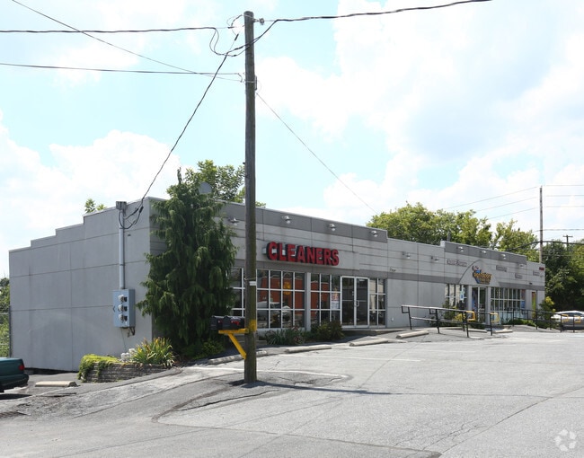
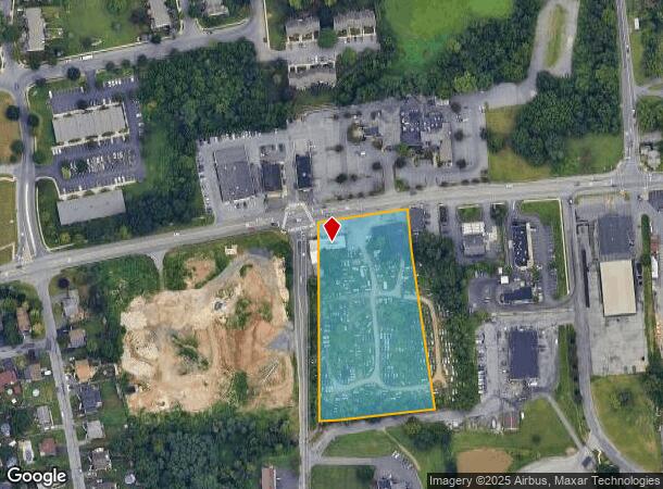
4406 Easton Ave
Storebuilding
Northampton
X
Pennsylvania
42095C0266E
3.84 AC
2025
Lehigh Valley
2025
Philadelphia
017607
Allentown-Bethlehem-Easton, PA-NJ
4,597 SF
M7-19-5-0205
DEMOGRAPHICS near 4406 Easton Ave
1 Mile
3 Mile
5 Mile
2024 Total Population
6,977
52,009
139,323
2029 Population
7,053
52,201
139,906
Pop Growth 2024-2029
+ 1.09%
+ 0.37%
+ 0.42%
Average Age
42
43
42
2024 Total Households
2,331
19,876
53,509
HH Growth 2024-2029
+ 0.94%
+ 0.36%
+ 0.39%
Median Household Inc
$114,001
$96,355
$82,895
Avg Household Size
2.60
2.50
2.50
2024 Avg HH Vehicles
2.00
2.00
2.00
Median Home Value
$309,658
$275,018
$261,183
Median Year Built
1995
1978
1969
Nearby Places
Map Layers
Map Styles
 Street
 Aerial
- Restaurants
- Banks
- Shops
- Fitness
- Groceries
PUBLIC TRANSPORTATION
AIRPORT
Lehigh Valley International
DRIVE
WALK
Distance
Lehigh Valley International
19 min
10.0 mi
Freight Ports
Port of Philadelphia
DRIVE
WALK
Distance
Port of Philadelphia
94 min
57.2 mi
SALE & LEASE HISTORY
LISTING DATE
SALE/LEASE

Sep 27, 2018
For Sale
Apr 05, 2018
For Lease
Nearby Properties
Address
Land Use
TOTAL SIZE
Lot Size
Zoning
Address
Land Use
TOTAL SIZE
Lot Size
Zoning
148,804 SF
22.75 AC
OB
Address
Land Use
TOTAL SIZE
Lot Size
Zoning
52,164 SF
124.81 AC
IN
Address
Land Use
TOTAL SIZE
Lot Size
Zoning
524,948 SF
35.66 AC
LI
Address
Land Use
TOTAL SIZE
Lot Size
Zoning
249,872 SF
41.83 AC
PC
Address
Land Use
TOTAL SIZE
Lot Size
Zoning
56,276 SF
14.91 AC
RR
Address
Land Use
TOTAL SIZE
Lot Size
Zoning
319,788 SF
60 AC
IN
Address
Land Use
TOTAL SIZE
Lot Size
Zoning
512,902 SF
35.18 AC
LI
Address
Land Use
TOTAL SIZE
Lot Size
Zoning
42,465 SF
7.28 AC
LI
Address
Land Use
TOTAL SIZE
Lot Size
Zoning
539,133 SF
47 AC
LI
Address
Land Use
TOTAL SIZE
Lot Size
Zoning
508,835 SF
34.92 AC
A
Address
Land Use
TOTAL SIZE
Lot Size
Zoning
208,053 SF
45.58 AC
I
Address
Land Use
TOTAL SIZE
Lot Size
Zoning
430,201 SF
17.30 AC
I
Address
Land Use
TOTAL SIZE
Lot Size
Zoning
257,186 SF
14.63 AC
G1
Address
Land Use
TOTAL SIZE
Lot Size
Zoning
56,276 SF
6.94 AC
RR
Address
Land Use
TOTAL SIZE
Lot Size
Zoning
229,448 SF
12.95 AC
GI
Address
Land Use
TOTAL SIZE
Lot Size
Zoning
312,950 SF
33.17 AC
A
Address
Land Use
TOTAL SIZE
Lot Size
Zoning
152,352 SF
17.18 AC
IN
Address
Land Use
TOTAL SIZE
Lot Size
Zoning
227,807 SF
12.09 AC
GI
Address
Land Use
TOTAL SIZE
Lot Size
Zoning
22,752 SF
10.17 AC
MHDR
Address
Land Use
TOTAL SIZE
Lot Size
Zoning
319,578 SF
27.91 AC
I
Address
Land Use
TOTAL SIZE
Lot Size
Zoning
137,060 SF
16.16 AC
OB
Address
Land Use
TOTAL SIZE
Lot Size
Zoning
3,055 SF
7.06 AC
OB
Address
Land Use
TOTAL SIZE
Lot Size
Zoning
97,066 SF
14.02 AC
MDB
Address
Land Use
TOTAL SIZE
Lot Size
Zoning
35,575 SF
35.21 AC
C
Address
Land Use
TOTAL SIZE
Lot Size
Zoning
1,800 SF
87.78 AC
RA
Address
Land Use
TOTAL SIZE
Lot Size
Zoning
243,750 SF
23.97 AC
A
Address
Land Use
TOTAL SIZE
Lot Size
Zoning
73,506 SF
6.32 AC
OB
Address
Land Use
TOTAL SIZE
Lot Size
Zoning
10,240 SF
12.86 AC
RM
Address
Land Use
TOTAL SIZE
Lot Size
Zoning
246,253 SF
17.71 AC
A
Address
Land Use
TOTAL SIZE
Lot Size
Zoning
1,536 SF
224.03 AC
RA
The World's #1 Commercial Real Estate Marketplace
Connect with us
© 2025 CoStar Group
The information above has been obtained from sources believed reliable. While we do not doubt its accuracy we have not verified it and make no guarantee, warranty or representation about it. It is your responsibility to independently confirm its accuracy and completeness. Any projections, opinions, assumptions, or estimates used are for example only and do not represent the current or future performance of the property. The value of this transaction to you depends on tax and other factors which should be evaluated by your tax, financial, and legal advisors. You and your advisors should conduct a careful, independent investigation of the property to determine to your satisfaction the suitability of the property for your needs.